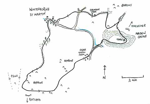
Dorset Walk – Maiden Castle and Winterbourne St Martin
Catherine Speakman takes a walk through the ages
Published in November ’19
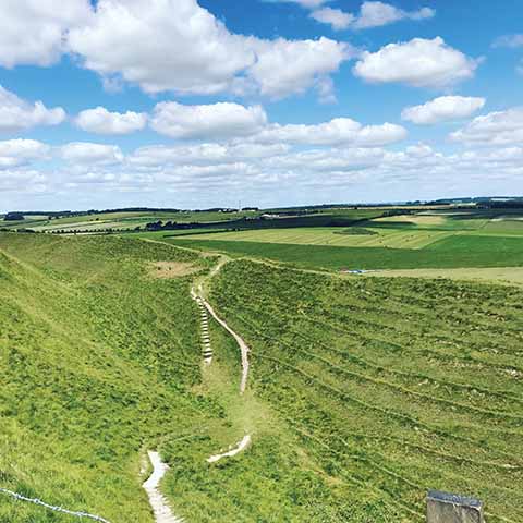
The impressive ramparts at Maiden Castle
FOLLOWING DOWN Maiden Castle Road in Dorchester and over the bypass, you enter a landscape that is strangely surreal. No development, few trees, numerous barrows, a wide open view dominated by the impressive earthwork remains of Maiden Castle, the biggest Iron Age hillfort in Europe – possibly the world! On arrival you enter an open car park, rarely full, so parking is easy.
To start the walk, head up the hill, following the path towards the castle but keeping to your right. When you reach the trees, aim for the gap between them, following the footpath sign away from the castle. After a small climb to the top of the field, the views open up again, but this time facing north. In the distance lies Prince Charles’s ‘village’ of Poundbury. It is his own idea of how a town should be designed, including environmental and social factors. Many covenants exist to maintain the estate: for example, houses and doors cannot be painted other than their original colour and bins are not allowed out on any other day than bin day. It led the way in introducing environmentally conscious attributes in planning, too, like houses recycling rainwater for their own use. Its design has been echoed across the country, but it is still in development and due to be completed in 2025.
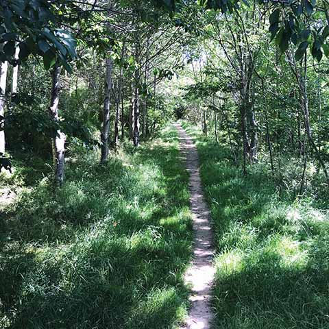
The walk takes a shady route through to Martinstown
Follow the path down to meet a track at a cross roads, turn left through a gate and walk towards Clandon Farm. Make your way around the farm buildings, staying on the main track. To the left you closely pass one of the many barrows, Clandon Barrow. It was excavated in 1882, when gold objects were found. At the end of the track, you approach a small junction. Head straight across to enter a field with its boundary on your left. As you walk through the two fields, the village and the 15th-century church tower of Winterbourne St Martin (also known as Martinstown) will come into view. This is a pretty little village with a stream running alongside the road, each property on that side of the road having its own little bridge to cross.
When you exit the field, turn left down the track, past the houses, and join the village road. Turn right and continue along the pavement to find St Martin’s church. Here, cross the road and take the track almost directly opposite the church. This is where the big climb starts. Make your way out of the village, staying on the track. When a corner appears, carry straight on into the field, heading down to a little wood. On entering the wood, it is a beautiful, clear, easy-to follow-path. To your left you can make out a small valley climbing up through the trees to meet your own height. As you exit the woods, you are faced with a wide view of fields and chalk hills with barrows high in the distance. Stay on the footpath and join a track. Turn left and follow it along to enter the final field you can see. Here you have another climb, but it’s worth it.
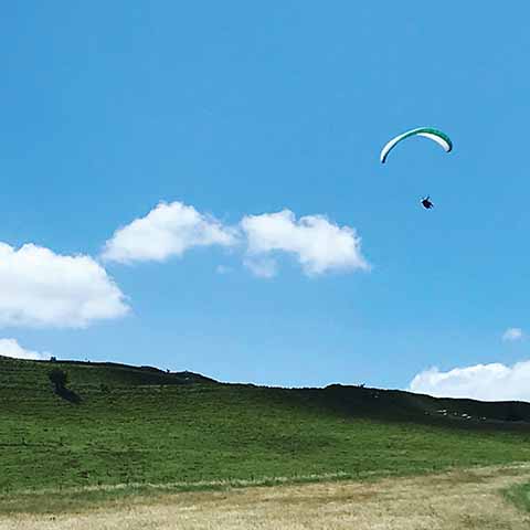
It’s not just walkers that take advantage of Maiden Castle
Continue in the direction of the track once it falters, walking straight through the field towards the pylons, that you won’t quite reach, and passing numerous barrows as you go. It is amazing how the barrows have survived the test of time. Originally they would have been capped in chalk, often situated in prominent positions, making them clear to view in the day but also making them glow in the moonlight. Few have been excavated but each one is expected, like Clandon Barrow, to contain not only skeletons but gifts for those who died to take with them to the underworld. Treasure everywhere!
Despite the barrows’ mystery, it is hard to ignore modern-day developments, such as the pylons. However, these are all due to be replaced by underground cables in the summer of 2020, so maybe try to appreciate them while we still have them, as next time the view will be astonishingly different.
At the top of the hill, at the corner of the field, you join the Dorset Ridgeway. The English Channel is in view to the south, with miles of the Dorset Jurassic coastline bordering it and the Isle of Portland sticking out like a sore thumb! To the north you can see as far as Hilfield Hill, north of Cerne Abbas. The total distance between the two, as the crow flies, is 20 miles.
Turning away from the pylons, follow the Ridgeway to the east, staying on the brow of the hill and once again passing a number of barrows. After walking along the ridge for just under half a mile, circling one barrow and arriving at twin barrows, divert north east, crossing diagonally along the field. On entering the next field, look to your left: not only will you pass a couple of overgrown barrows but behind them, in the little woods, are more. The landscape is littered with this activity.
As you come back down into the Winterborne valley, Maiden Castle dominates the horizon. Make your way through the next field, heading to Higher Ashton Farm. Follow the road out of the farm and turn left when you join the road. This is a small country road, so keep your ears open for traffic, but you are not on it for long. When a fork in the road appears, take the right and follow it downhill to the river. Take the right again and when the road turns sharply, take the footpath through the gate. You are now at the bottom of Maiden Castle. As you can expect, it’s a climb again, but there is nothing better to demonstrate what a highly efficient defensive site this was.
 Once you feel that you are at the top, you do have the choice of heading straight over the brow of the hill, skirting the castle and returning to the car. Alternatively, you could conquer the ramparts. These were the deep defensive banks that protected the castle when it was in use. An excavation in the 1930s around the eastern entrance to the castle produced numerous skeletons, a lot with evidence of death from battle, for example a ballista bolt embedded in a spine. These finds are shared between Dorset County Museum and the British Museum in London. Evidently the Romans took the castle successfully by force before settling in Dorchester (or Durnovaria as the Romans called it).
The earthworks of the castle itself are more than impressive. Nevertheless, there is a stone ruin, too: a Roman temple, now mainly frequented by sheep. To reach it, it is best to make your way along on the highest part of the castle. As the opposite, eastern entrance to the site comes into view, turn left. The ruin itself is nothing more than the remaining foundations, so you need to keep your eyes peeled. It is also easy to be distracted by the views, especially to the north, taking in the town of Dorchester.
Your path back to the car can be your own adventure, but it is always important to remember the risk of erosion by foot traffic, so best to stick to the footpaths rather than making a new one.
WALK DETAILS
Distance: 6 miles/9km
Time: 2.5 hours
Total climb: 570 ft
Max height: 538 ft
Min height: 260 ft
Terrain: Track, path and field.
Exertion: Medium, but some of the climbs can be tough. Some mud after rain.
Start: Maiden Castle car park (Grid Ref: SY668889, Postcode DT2 9EY).
Map: OL Explorer 15 South Dorset
How to get there: From Dorchester, head south on to the Weymouth road. After the traffic lights take the third right, signposted for Maiden Castle.
Dogs: On leads where livestock is present and in accordance with any notices on the walk and the Countryside Code.
Refreshments: Nowhere on route, but the town of Dorchester has many options.
