Dorset walk – Tarrant Crawford & Spetisbury
Teresa Rabbetts goes walking where the Tarrant meets the Stour
Published in January ’19
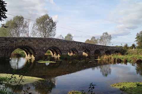
Crawford Bridge
These days Tarrant Crawford is scarcely more than a small scattered community consisting of a handful of buildings, most of which are sited within half a mile of the church. However, a clue to the former importance of the settlement can be found in the name of the one farmhouse and associated barns which remain next to the church – Tarrant Abbey.
Tarrant Abbey thrived and prospered under King Henry III, who maintained royal patronage after the death of his sister, Joan, endowing the Abbey with many gifts including half of the manor of Bere Regis in 1269. Prosperity continued until the dissolution under Henry VIII, when most of the nunnery buildings were destroyed.
Rising as a winterborne on Cranborne Chase, the River Tarrant cuts through the valley, gaining depth and width as it travels. Originally referred to by the ancient British name Terente, which translates as ‘trespasser’ or ‘river that was liable to flood’, the lower stretches of the Tarrant certainly flow during the winter period, frequently causing floods along its course.
Crawford probably meaning ‘crows’ ford’ possibly refers to a ford that was situated where Crawford Bridge now stands. Although winding merely seven and a half miles through quiet North Dorset countryside, the River Tarrant asserts its importance by providing names to eight settlements, from Tarrant Gunville to Tarrant Crawford, the last of the Tarrant villages, before merging with the River Stour just after Keyneston Mill.
Near the site of the former abbey in a quiet valley is the simple and beautiful St Mary’s church, dating back to the 12th century. There is a strong sense of atmosphere which greets you as you step into the nave – electricity never reached St Mary’s. The unlit interior is plain and unpretentious with a wagon roof, an exposed roof structure, clear glazed windows, oak pews and a sloping stone floor. Most impressive of all, though, are the faded wall paintings on the south wall. Dating from the late 14th century, the ghostly painted tales were sited to instruct early parishioners – they tell of St Michael weighing souls at the Last Judgment, St Christopher carrying the Holy Child, the scene of the Crucifixion, the life and sufferings of St Margaret of Antioch (who was said to have been swallowed by the devil, shown here in the form of a dragon) and three skeletal princes who provide a judicious morality tale about ‘the emptiness of earthly rank and wealth’.
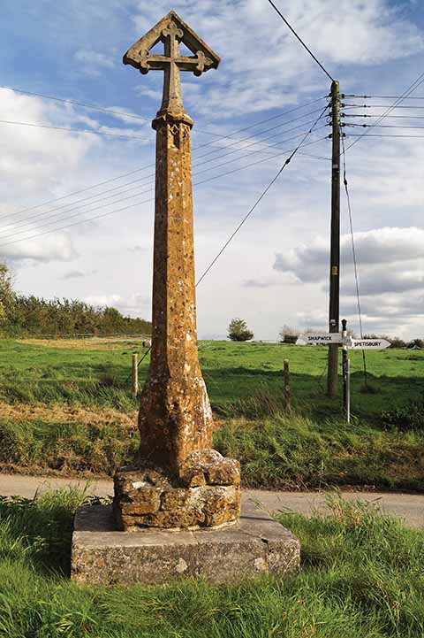
Tarrant Crawford Cross
As medieval visitors travelled to and from Tarrant Abbey, they would have passed through the lanes, going by Tarrant Crawford Cross. The tradition of erecting wayside crosses dates from the 9th to 15th centuries. They served several functions: not only did they reinforce the Christian faith, (some early crosses re-used prehistoric standing stones), but they also acted as waymarkers to link settlements or indicate routes, particularly between religious settlements. As with so many structures across the country, many wayside crosses were damaged during the Reformation or the Commonwealth, but there are approximately 350 crosses remaining across the country, particularly concentrated throughout Devon and Cornwall.
Tarrant Crawford Cross, at the junction between Shapwick, Tarrant Crawford and Spetisbury, is thought to date from the 15th century and, although the cross was raised onto new steps and the head replaced in 1914, Historic England believe that it is relatively well-preserved and, as it survives in its original location, it is an important example. Although Tarrant Crawford now consists of few dwellings around the junction, there are earthworks of former house sites in adjacent fields, a reminder of the former size and importance of a now depleted settlement
THE WALK
1 After parking, return to the A350 and cross with caution to Louse Lane opposite. Turn right and up the ramp to follow the old Somerset and Railway track route, the Trailway, towards Blandford. If you want to explore the nearby Crawford Castle/Spetisbury Rings, then go over the stile immediately on the left and, keeping the hedge on the right, follow the path arrows to the hill fort. There is an obvious path around the Rings which leads you back to the lane where you turn right and go up the ramp just before the bridge to rejoin the Trailway route.
2 Continue along the Trailway for just over a mile, pass through Spetisbury station and then under a bridge (there are a number of footpaths on either side of this section but ignore them). Continue until reaching Spetisbury School on the right of the path. Leave the Trailway just before a road bridge and walk down a ramp and into the lane next to the school.
3 Walk down the lane and cross the A350, then follow the Keyneston Mill footpath which passes in front of Clapcott’s Farm. When you reach two garages, follow the left path, which passes over a long bridge through gardens, then continue over the gravel drive and bridge before turning left onto the footpath which passes Mill House. Follow the route through the trees and enter fields. Now cross two fields and walk towards a footbridge which crosses the Stour, to Keyneston Mill.
4 Past Keyneston Mill, the path turns sharply right and is fenced for a short stretch. Follow the clearly trodden route with the river and trees on your right until reaching a lane. Cross the lane and see the post which indicates St Mary’s Church – follow the route up the unmade road, eventually passing Tarrant Abbey Farm on the right before reaching the church.
5 On leaving the church, follow the path as it rises slightly uphill. The remaining Abbey walls are on the left and Tarrant Abbey Farm on the right. The path continues to the road, where you turn left and walk until reaching the Tarrant Crawford Cross where you turn right (signposted to Spetisbury) and return to Crawford Bridge.
Park & start: Travelling north on the A350 Sturminster Marshall to Blandford road, turn right on entering Spetisbury into Mill Street. Proceed slowly as the road goes over Crawford Bridge until reaching a very small parking area on the left of the road.
Terrain: Mostly easy. Following the river, much of the route will be muddy during the winter or after rainy periods. The terrain offers varying conditions – road, tracks and muddy paths across water meadows.
Distance: 4 miles
Maps: OS Explorer 118 Shaftesbury & Cranborne Chase, OS Landranger 195 Bournemouth & Purbeck
