Lyme Regis: then & now in photos
Angus Rich sees how much and how little the town has changed in a century
Published in September ’18
Despite its presence in the Domesday Book and its two royal charters in 1284 and 1591, the literary connections of Lyme Regis might lead one to assume that the richest part of its history was from the Napoleonic Wars to the mid-19th century: from Louisa Musgrove’s fall in Persuasion to the French Lieutenant’s Woman gazing out to sea.
In photographic terms, Lyme Regis really began to make its mark pre-World War 1. In the case of this feature, all the original pictures, bar one, were taken between 1900 and 1910.
One of the differences between the older pictures and their modern equivalent is, perhaps surprisingly, just how much more populated with people the older pictures are. This probably has as much to do with the high daytime temperatures in the month of the modern shoot and the consequently early hour of photography as it does with the fact that a photographer setting up his bulky plate camera with tripod was still perhaps an event in itself in Edwardian Lyme Regis.
The single shot that could qualify as a candid, or possibly environmental portrait in Lyme Regis is from 1940 and is of the harbour and Cobb. This was an unusual and possibly quite risky time to be taking pictures of England’s south coast. There’s nothing obviously lurking to defeat a possible invader, so we’re probably looking at Lyme Regis before June 1940; after Dunkirk, the south and east coasts of England were covered with anti-tank defences, mines and barbed wire.
With the exception of the departure of shops and railway station, the footprint of Lyme Regis as shown in these pictures has not really changed at all over 100 years. Individual buildings have come and gone, been changed, extended or indeed reduced in size.
Almost unchanged – with the exception of the neatness of the foliage in front of it – in one of the Coombe Street shots is the former Congregational chapel where Mary Anning was baptised and later worshipped. Now it is the Dinosaurland Fossil Museum established by the former chief palaeontologist of BP, Steve Davies, 29 years ago.
Quite a number of properties show first-floor bay windows with nothing supporting them underneath and nothing above them. These seem to have been either removed or the bays extended downward and upwards for, respectively, stability and space.
In some places the nature of the use of the buildings has changed – often from shops to private residences in the back streets – but little else has. It is also true – after extensive research was conducted for the sake of accuracy – that a commendable number of Lyme’s public houses are still plying their trade a century on.
Almost like the fashions in hemlines and lapels, chimney stacks have got smaller while kitchens have got larger. Walls where there was an imminent chance of collapse (or indeed possibly did have a collapse) have got shorter and been replaced with fences or simply left low. Finally, cast iron railings seem to have survived rather better than in other Dorset towns, albeit again not all at full height.
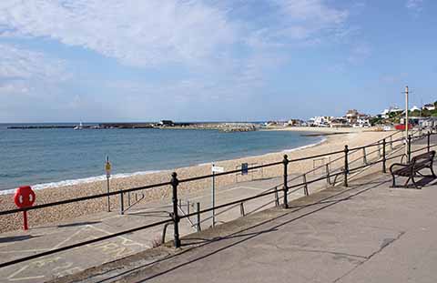

NOW (top) Early morning on what would be a blisteringly hot day, the beach is as yet deserted but, just at the limits of one’s perception, there is someone at the end of the Cobb channelling John Fowles’s French Lieutenant’s Woman
THEN (above) This 1940 shot shows people bathing on the beach, so it was presumably taken before the end of the phoney war in May 1940. The full-length coats worn by the two people in the foreground suggest that it is not high summer. Credit www.barriepictures.co.uk
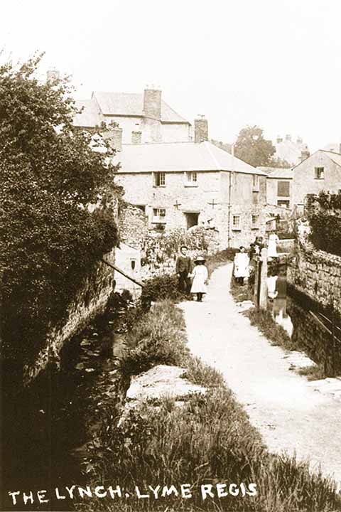
THEN (Top) The large wall on the left, optimistically held up by a single prop, did not last the course. The leat taking water to the Town Mill is as it was, though. Credit www.barriepictures.co.uk
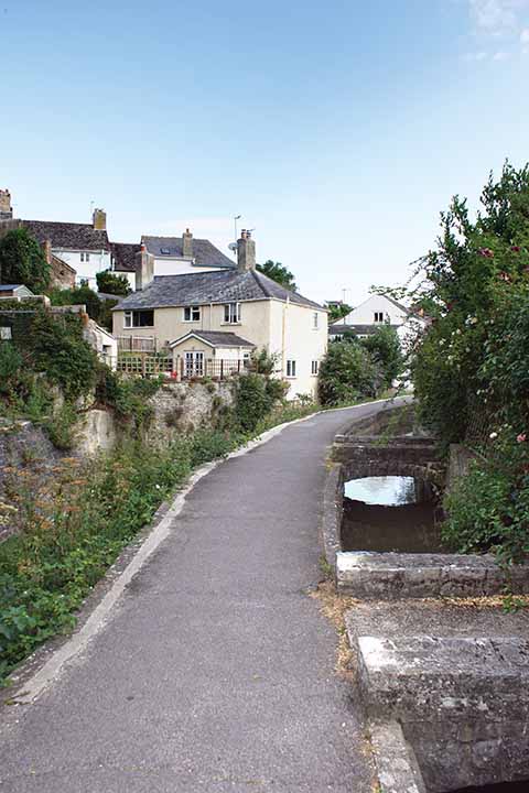
NOW (above) The angled wall now on the left is rather stronger. Note the number of extensions as various buildings have grown, while their chimney stacks are smaller or completely gone.
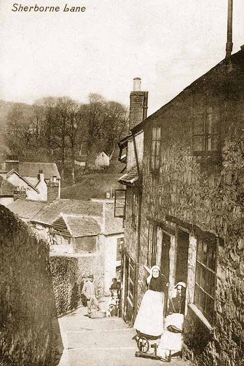
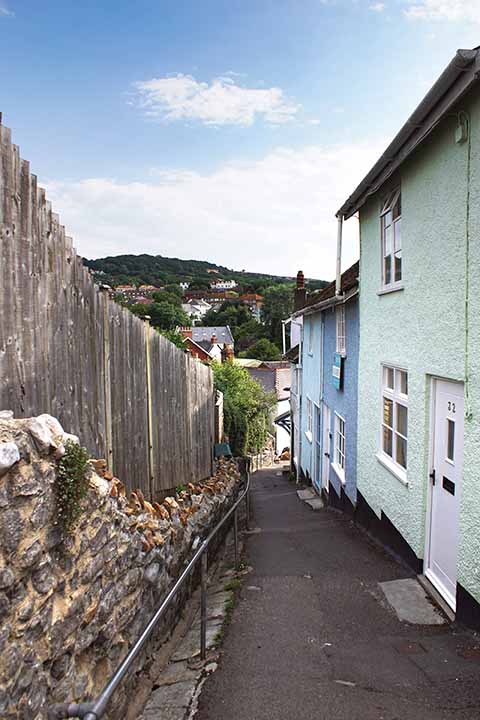
THEN (top) Most noticeable in this shot looking down the end of Sherborne Lane is the huge wall on the left of the lane and also the near-absence of development on the other side of the valley
NOW (above) Not only are there more buildings on the other side of the valley in the modern shot, they are substantially bigger buildings as well, as can be seen from how they dominate the trees. The wall failed to last out the century and now tops out at around hip height.


THEN (Top)Quite a lot of evidence of horse-drawn transport on the road, as well as what looks like a spilt load of coke and a Dutch barn-styled roof on the building beyond the ‘high class stores’. NOW (Above)The Pilot Boat Inn in its traditional Bridge Street position. The Dutch barn building has lost its top storey and distinctive roof.
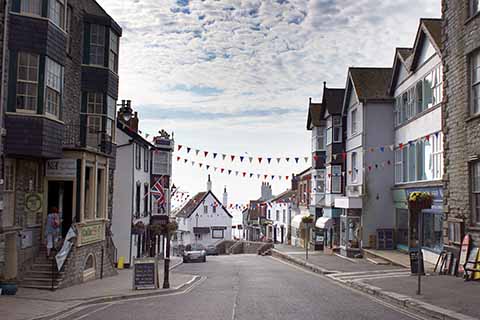
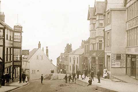
NOW (top) The Royal Lion has given over its advertising signage spot from Edwardian times in favour of reprinting the motto of the Prince of Wales beneath his feathers. ‘Ich Dien’ is also quite an appropriate motto for a pub as it means ‘I serve’.
THEN (above) Broad Street, has much more living accommodation opening onto the street than today. Like all Edwardian high streets, it had its furnisher/undertaker.
