The Dorset walk – Thorncombe & Laymore
Paul Quagliana heads for the western edge of the county
Published in September ’19
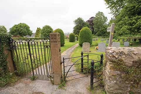
The entrance to Thorncombe church’s graveyard, through which a footpath runs
It’s 175 years this year that Thorncombe became part of Dorset as part of a process to get rid of historically logical, but geographically nonsensical, enclaves. So, thanks to the Counties (Detached Parts) Act of 1844, Dorset’s Axminster, Stockland and Dalwell became part of Devon, while Holwell moved from Somerset to Dorset and Thorncombe ‘moved’ from Devon to Dorset.
Thorncombe village has a shop (opposite the parish church of St Mary the Virgin) with a visiting post office on Mondays and Wednesdays. The Bragge family of Sadborrow were largely responsible for the building of the present church in 1866-67. Laymore is a hamlet, but one with a pub – the Squirrel Inn.
Rapehole Coppice was an ancient woodland, some of which was cleared in the 1960s for agriculture. It looks like a pair of green brackets from the air, around the fields that ate its heart.
THE WALK
1 Passing St Mary’s Church on your right you find a black metal kissing gate and a wooden footpath finger post. Go through the kissing gate and through the graveyard. Go through a small metal gate exiting the graveyard, across short grass and continue ahead towards houses/garages. At the houses turn right. Head towards the right hand end of the house/garages and go around them. There’s a tall wall on your left and a narrow path heading downhill with a tall hedge on your right. At the bottom is a wooden stile that leads onto a lane – ignore it and instead turn sharp left over a wooden stile into a grassy meadow.
Head gently uphill towards a corrugated barn with a gate just past it. Go over a wooden stile next to the gate and turn right and head downhill. The path is not visible but keep going gently downhill passing gorse bushes on your right heading towards the bottom right hand corner of the field. A hedge meets trees in the corner of the field and here should be a wooden stile. Go over the stile and continue with trees on your right. Keep going with trees on your right.
You will come to a gateway, go through this. Initially you will have a hedge on your left but soon peel away from the hedge and head downhill to the middle of the trees ahead. There is an opening in the wood. Go through the opening and below you will see a wooden bridge over a stream, go over it and turn left. Go over a wooden stile and continue ahead. You will see metal gates to the sewage works and a paved lane. Turn right up the lane to the road.
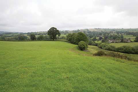
There are bucolic views aplenty on this walk
2 At the road turn left, crossing a small bridge. Just after go over a stile into the field by a footpath sign. As you cross the stile you will see a gateway in a hedge to the left of a large tree and another gate on the hilltop in a hedge-go through/over both. After the second gate turn left, walk with the hedge on your left to a wooden stile, then go straight across the field to where the wood meets the hedge. Go slightly uphill through a short patch of vegetation, at the edge of the wood go through a metal gate to a large open field ahead. Turn left, and follow the field edge with the wood on your left. When you pass a pond below and to the left in Oxenleaze coppice, keep going, with the woods on your left, and you will go through a small metal gate in a hedge on your left.
With the hedge on your right now you will see a wooden bridge to your left – ignore it and go over the stile on your right into a field. Keeping to the edge of the field head gently uphill with trees/woodland on your left. The wood bends outwards slightly and here you will see a wooden stile that allows you to enter the wood – go over it. Inside the wood is a narrow earth path that follows the edge of the wood slightly uphill. Go over the wooden stile at the end of the path.
On leaving the wood you will find a broader grassy track, continue ahead on it. You will meet a cross tracks – go straight over. You will be on a stony, grassy track passing a lake on your left. As you leave the lake, do not follow the stony track, but on its bend continue ahead with a hedge on your right towards the beginning of a small wood. You will pass through thick grass with no discernible path to the edge of the wood.
Go over a collapsed fence into the wood and walk on an earth path. The path continues through the wood and is slippery in places. Keep going keeping just inside the wood, ignore a small stile on your left and keep going. You will reach a larger wooden stile-go over it and leave the wood. Turn right, walk uphill in a grassy field until you reach a wooden stile set in a hedge into a boggy rough bit of ground – head uphill towards buildings. The ground soon becomes grass and head to the right hand corner of a low red brick building. As you round the corner of this, you will see a metal gate ahead – go through the gate. You will now be in the car park of the Squirrel Inn.
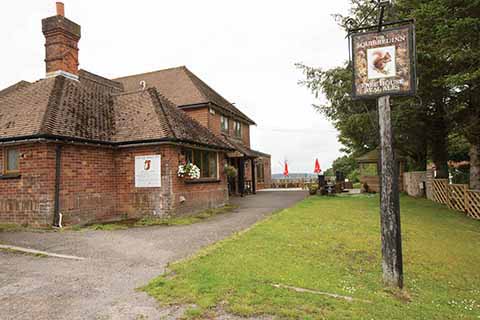
Not many hamlets have a pub. Laymore is an exception.
3 Walk across the car park to the road and turn right. Walk along the road ignoring any turnings. Soon the road bends to the left and you will see a footpath marker on the left – cross the road and follow this. Head gently downhill keeping trees on your left. You will see a house away to your right ahead. This is Barn Cottage. As the tree line bends slightly leftward head diagonally right across the field aiming about 30 yards to the left hand side of the cottage. At a wooden post with a faded footpath marker follow a grassy track with Barn Cottage now on your right until you come to a metal gate. Head gently downhill keeping a strip of trees on your left. You will come to a large oak tree in the field, go around it and back to keeping the tree line on your left. You will soon reach a broad stony track on the corner of the wood. Go over it and through a gate. You should see the tip of a communications mast and farm buildings to the right of it – head across the field aiming in between the mast and the buildings. Keep going towards a low grey building. At the low grey building turn left down a track. Pass the building on your right.
Shortly after that you will meet a cross tracks; turn right here. Follow the track around. There is a track to the left down to Dairy House and just past it a gate. Go through the gate. Head downhill with a hedge and Dairy House on your left. The hedge turns left, but here leave it behind and head downhill diagonally left across a large field to the bottom corner where a wood can be seen.
4 At the edge of the wood in the bottom corner is a barbed wire fence and a track beyond it. Go over the fence and turn left. Walk up the stony/earth track. The track meets a T-junction of tracks with a metal gate ahead. Turn left here following the grassy/stony track. The grassy track meets another track by a tall trimmed coniferous hedge. Turn left here and continue along a stony track. The stony track passes through fields. The stony track now passes the car park for Magdalen Farm on the right and you will meet two tracks and a metalled lane. Turn right down the metalled lane into Magdalen Farm yard. In the farmyard pass a large barn on your left with stone buildings on the right.
5 At the end of the barn turn left and follow a stony track. You will meet a metal gate and a wooden kissing gate, go though this. Initially follow the wood keeping it on your right, ignoring a wooden gate into the wood. Past the wooden gate leave the wood and head across a grassy field to the hedge where there is a wooden stile over a metal gate. Take care crossing the stile as it goes straight onto the road. Go straight over into a large grass field. Bear left diagonally downhill towards two large trees.
Go through a metal gate in the hedge and continue towards a single tree and a hedge that meets it from the left. Go past the tree. As you pass the tree keep the hedge on your left and keep going downhill. You will come to a wide grassy track that leads downhill with trees on the right, to a gate and the road. You will come to a wide grassy track that leads downhill, to a gate and the road. Turn right down the road for a short distance and you will see a stony track on the left.
Cross the road and go up the stony track a short distance. The track bends to the left and on the bend is a metal gate beyond which is an earth/grass track – go through the gate and up the track. The track becomes earthy as it runs inside and along the edge of a wood. Stay on it and you will see a ravine/stream on the right. The track drops down to a wooden bridge. Go over the bridge and turn left. You will soon see another wooden bridge in a hedge. Go over it and bear slightly right up hill across a grass field.
You will come to two metal gates, go through the right hand one and follow the hedge keeping it on your left. Keep going ignoring a metal kissing gate on your left. You will come to another metal gate, go through this and continue with a hedge on your left. Keep going slightly uphill and come to another metal gate – go through this. Beyond the gate is a earth/grass track stay on it and keep going. The track reaches the road in Thorncombe. Turn left here and walk down the road. Pass St Mary’s Church of England Primary School on your right. Soon you will be passing St Mary’s Church on your left and you can go back to your transport.
Total distance 5.15 miles
Total ascent 520 feet
Total descent 541 feet
Max Height 489 feet
Min Height 260 feet
Terrain: A real mix of downland, field, tracks and woodland. The Marshwood Vale can be claggy and clay-ey after rain.
Start: Park considerately in Thorncombe. OS Reference ST375032. Postcode TA20 4NG.
How to get there: Take the B3164 from Broadwindsor until it meets the B3165, where turn right and immediately left. Continue on this road until you reach another T-junction, then turn right into the village.
