Dorset walk- Hilton & Bulbarrow
Paul Quagliana takes a stroll in the hill country of the very centre of Dorset
Published in July ’19
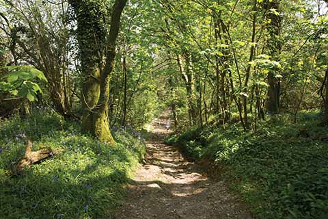
The first section of the walk includes some shaded tree-lined paths
Hilton sits 135 metres above sea level and, depending on where you measure from, is about as close to the geographical centre of Dorset as it is possible to get. It was formerly part of the Hambro family holdings of Milton Abbey. In 1870 it had a population of 833 (now 477) and was described in the Imperial Gazetteer of England and Wales as having ‘162 houses, the property is divided among a few. Orchards and gardens occupy considerable space. Slate, coal, and bog iron abound; and some gold has been found. There are many mineral springs. Druidical remains, Roman urns and coins, early English coins, and other ancient relics have been found… The church is tolerable, and has a tower.’
The church in question is All Saints, and ‘tolerable’ seems rather faint praise, given its rather splendid windows taken from Milton Abbey’s cloisters and the early 16th-century painted panels of the twelve apostles.
The original woodlands were managed for pheasant shooting parties organised by the Hambros and with guests including Edward VII. Much of the tree cover now is of post-war ash and beech plantations.
The high-point of this walk both figuratively and literally is Bulbarrow. It is respectively just five metres and three metres lower than Dorset’s highest points at Lewesdon Hill and Pilsdon Pen, and offers views across Dorset, but especially of the Blackmore Vale.
Bulbarrow is one of the few hills in Dorset to be immortalised in song, featuring in a track by the seminal surrealist band Half Man Half Biscuit, who famously split for four years citing ‘musical similarities’ as the reason.
THE WALK
1 Park in Hilton and opposite the entrance to the church is a sign for The Knapp and a wooden finger post to Bulbarrow. Go up here with a metal and stone fence on the right and a thatched cottage on the left. The metalled lane climbs, keep going ahead and it becomes a stony bridleway. You will come to a large metal gate and a smaller metal gate to its right. Go through the smaller metal gate and follow the bridleway as it ascends with a hedge either side. The bridleway continues to climb passing through trees before starting to level out. You will come to a wooden marker indicating a metal gate on your left, and an opening sharp right that leads to a field. Ignore either turning and continue straight ahead. The track becomes earth and stone and descends quite steeply though the woodland and soon ahead you will see a metal gate with Greenhill Nature Reserve on it.
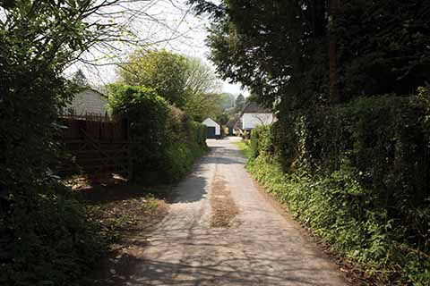
Section 3 Picture 19. The return into Hilton towards the end of the walk
2 Go through the metal gate and turn sharp left and follow an earth path that runs just inside the wood. You will come to a metal gate and a smaller wooden gate to its right. Go through the wooden gate and continue ahead, keeping a hedge on your left. This path is largely grass as you follow it around the edge of the large field with woodlands away to your right beyond it. You will come to a metal gate, go through it and continue ahead. The path become a track and enters largely beech woodlands. Go through another metal gate and on your left you will see a stone shelter built as a memorial by the friends and family of Mark Batchelor. It is a pleasant place to rest and there is a visitors’ book to sign. The track continues with a hedge on one side and a fence on the other. Ignore any turnings and pass the farm on your left. Keep going ahead through pleasant beech woodlands until you reach the road with a new-build house on the right.
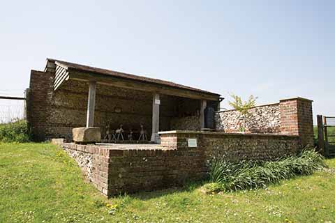
The stone shelter built to the memory of Mark Batchelor
3 Turn left at the road and follow it, passing the farm on your left and tall metal masts on your right. Pass some beech trees on the left and shortly after, the road curls gently to the left. There is a bridleway sign on the left, leave the road and follow this. Go through a metal gate (there is the option to go around it) and continue ahead on the bridleway. You will come to another metal gate. Go through it and immediately turn right following the edge of the field and fence down to a wood. Stay on the edge of the field following the wood, keeping it on your right. In the corner of the field where the wood ends is a metal gate. Go through this and head downhill on a broad grassy track. The track curls to the left, keep going and you will see a broad valley away to your right, and a high bank/hillside and gorse to your left. Keep going, heading downhill on the grassy track to some farm buildings. Just past the buildings is a metal gate on your right with two small buildings just beyond it. Go through the gate, walk towards the buildings and you will see a grass path that goes left from the buildings and leads across the field towards another single building.
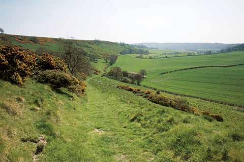
There are expansive views of the surrounding countryside leading up to, at, and coming down from the walk’s highest point at Bulbarrow
4 When you reach the single building go through a metal gate and you will see a broad track ahead of you with a fence on either side. Pass the building on your right and continue ahead and stay on the track. Keep going and you will go through a metal gate, continue ahead, and soon the track curls to the left with a metal gate and entrance on the right. Stay on the track and keep going following it leftward. You will pass some boggy ground with a pond or two on the right and ahead is a large barn on the left. By now the track has become a tarmac lane. Pass the barn and continue ahead. You will come to a small corrugated metal building ahead, bear right here and continue. You will see houses ahead and the lane turning to the left. Stay on the lane and it meets the main road in Hilton – this is the other end of The Knapp. You can now walk back to
your car.
Distance: 3.8 miles
Terrain: The village of Hilton is about 140m lower than the peak of this walk at Bulbarrow, so there are climbs and descents. Generally good underfoot, less so in wet weather.
Start: Park considerately in Hilton Village. OS Reference ST782030. Postcode DT11 0DG.
How to get there: From Blandford and Dorchester on the A354, at Milborne St Andrew, head north on Milton Road for 2.4 miles, then skirt Milton Abbey School (keeping it to your left) for two miles until you reach Hilton.
Maps: OS Explorer 117 (Cerne Abbas & Bere Regis) and Landranger 194 (Dorchester & Weymouth)
Refreshments: None on route. The Fox Inn in Ansty (DT2 7PN) and the Hambro Arms at Milton Abbas (DT11 0BL) are each around a five-minute drive away
