The Dorset walk – Swanage
Matt Wilkinson and Andy Farrer take a route round one of Dorset’s most popular resorts
Published in January ’18
Swanage’s continuing popularity is a tribute to both its interest and charm, not least the beauty of its bay, held in the arms of Ballard and Peveril Points. Some may feel that the crowds that descend in high summer are a high price to pay, but that is the nature of a seaside resort and essential for its economic well-being.
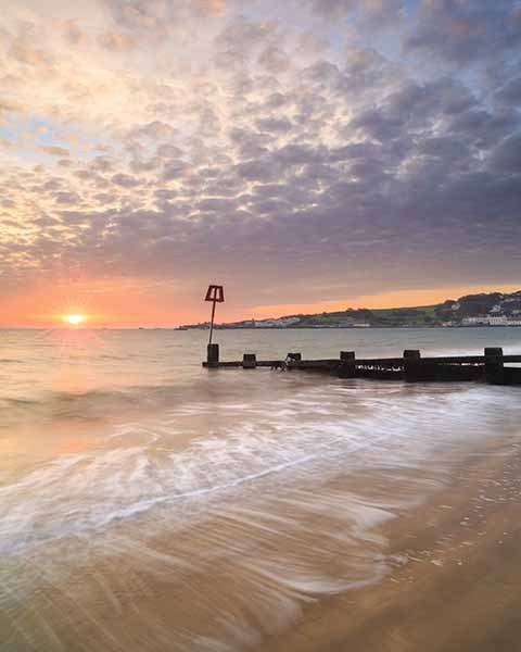
Looking southeast towards Durlston Head from Swanage Beach at first light
Tourism is a comparatively young industry, and for centuries before the trippers arrived, that economic well-being depended on Swanage’s role as a port for the shipping of stone brought down from the quarries on the hills to the south and west of the town. Still embedded in the seafront by the Stone Quay are the rails along which horses would draw the carts bearing the stone to the waiting barges. The idea of Swanage as a tourist destination was not born until the railway reached the town in 1885. At that time, the main road was the one along the hills, past the quarries, not the track that led along the valley and today is the main A351.

Durlston Bay with Swanage Bay beyond
Swanage is still a working port for fishing and dive boats, all of whom treat warily the fierce ledges off Peveril Point. This walk also passes the pier, which is the answer to a useful pub question: ‘Which pier on the South Coast runs from south
to north?
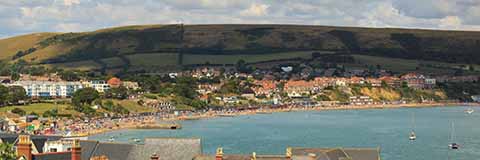
A panoramic view of Swanage Bay from Peveril Point
The great names in Swanage’s history are John Mowlem and his nephew, George Burt. Both made their fortunes as builders in London and generously endowed their home town. Perhaps their most famous legacy is the Great Globe, the 40-ton sphere installed by Burt in 1887 under the walls of Durlston Castle.
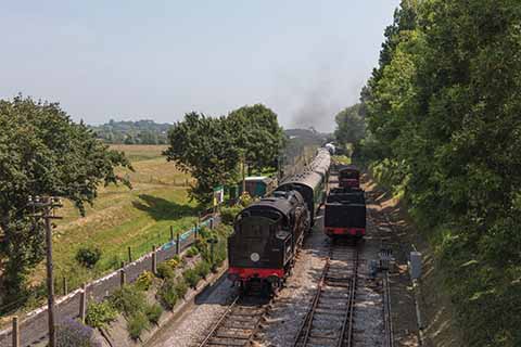
The route crosses a bridge over the Swanage Steam Railway
George Burt built the castle, too, and today it is a visitor centre for both the Jurassic Coast World Heritage Site and Durlston Country Park, part of which was Burt’s estate. Rich in wildlife and with wonderful sea views, it is one of Swanage’s most valuable assets.

The Anvil Point lighthouse and coast guard cottages
THE WALK
1 Walk back down to the main road, turn right and then take the first left, which is Washpond Lane. After crossing the Swanage Railway at Herston halt, the lane bends sharply right and left, then rises. Just over the top of the rise, as the lane begins to descend, cross a stile on the right and follow the left-hand edge of a field to the second opening on the left, into a larger field which is used for camping in the summer. Leave this field by an opening in its right-hand edge about 80 yards short of the far right-hand corner and cross a plank bridge. In the next field, go through a gate just to the left of the bottom left-hand corner and follow a well-defined path across the next field to leave it by a gap between a hedgerow on the left and a fence on the right with buildings beyond it. Follow the fence to another gate, which leads onto an enclosed path down to a road.
2 Turn left and take the first proper turning on the left, which starts as a paved lane. In 20 yards keep a sharp lookout for an overgrown stile on the right. Cross this and bear left diagonally up the field. Over the brow of the rise, head for the bottom right-hand corner, where cross a stile on the right onto a grassy path along the top of some allotments. Take the first right onto a track, then in about 50 yards turn left by a water-trough on a grassy path running between the allotments. The path merges with a paved lane. Turn left and almost immediately right at a T-junction. Walk down the road to a T-junction, where turn left and almost immediately right into Battlemead. At the end of Battlemead, once again turn left and almost immediately right.
3 At the next T-junction, turn right and follow the road down and round to the seafront. Walk along the seafront – on the pavement or beach, according to preference – and through the arcade to the left of the Mowlem Institute to the Parade and the Stone Quay, continuing to keep close to the waters of the bay on the left. At the entrance to the pier, turn right for a few yards, past the entrance to Swanage Sailing Club, and turn left on the road. Where the way forks, take the lower, left-hand option, but when it forks again, take the right-hand option, alongside a stone building to the right. This path ends at some steps. Climb them and turn left on a road. Where the road forks, with the Wellington Memorial directly on the left, take the right-hand option and follow it right to the very end of Peveril Point.
4 Here turn right and follow the top of the cliff. Be prepared for diversions round rock falls, but these are usually well signed. The path soon goes up the edge of the large open grassy area known as the Downs and at the top enters a much smaller area which is crossed to a gate in the far right-hand corner. This leads to a road, where turn left, but in about 100 yards, just past two parking spaces, look out for a metal gate on the left. Beyond are steps which lead to a path that curls through woodland before reaching steps up to a path that rises comparatively gradually and which eventually emerges at the top of some steps down to the area in front of Durlston Castle.
5 Either walk through the castle to enjoy its displays, exhibitions and other facilities, or take the path to the left of the castle, which leads down and round to pass the Great Globe. Stay on the same path all the way to the lighthouse at Anvil Point, where continue along the coast path to go through the first gate. Then bear right and climb to the top of the ridge, where you should go through a kissing gate and turn first right and then left to follow the path along the highest part of the ridge, above the sea. When a five-barred wooden gate with a smaller gate next to it comes into sight on the skyline, turn slightly inland to go through it. The path immediately forks; take the right-hand, more inland option.
6 Cross a large field, go through a gap in the wall and, at the far side of the next field, turn right to follow the wall on the right uphill and inland. After two fields the path becomes a track. Follow this straight ahead and over the rise until it bends left into a field. Here continue on a path to a cross-paths in front of Belle Vue Farm, where turn right and then almost immediately left. Continue downhill to a clearing just before the first houses of Herston. Here turn left to reach a paved lane in a few yards. Turn right and walk down to a T-junction, where turn left. This is Higher Days Road, which becomes Days Road, where your car is parked.
Distance: About 6½ miles
Terrain: Good underfoot but there are some steepish, if generally short, climbs
Start: Days Road, Herston. OS reference SZ013788. Postcode BH19 2JP.
How to get there: Follow the A351 into Herston, on the western edge of Swanage. Days Road runs up to the right, opposite the beginning of the buildings of the Swanage School.
Maps: OS Explorer OL15 (Purbeck & South Dorset), OS Landranger 195 (Bournemouth & Purbeck).
Refreshments: Many places in Swanage, particularly during the summer season. Durlston Castle.
